
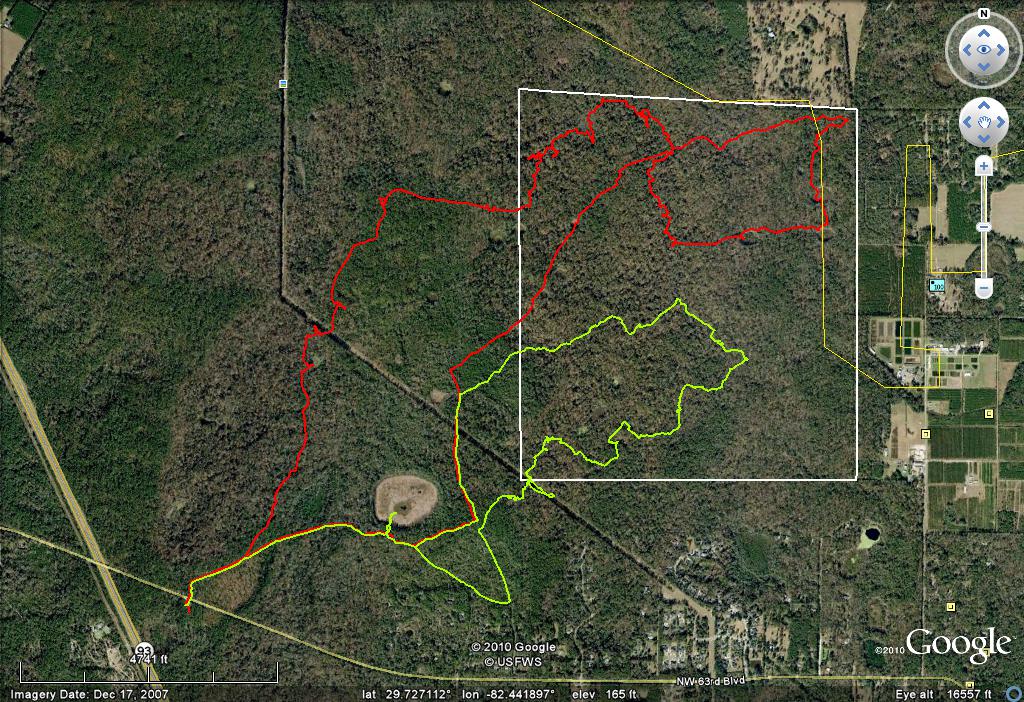
Twice recently, I hiked into a part of San Felasco Hammock Preserve State Park that I have never before visited, traversing 6.2 and 9.9 miles. That area is along the eastern boundary about half-way between Millhopper Road and the park’s NE corner, just about as far from either trailhead as you can get. The first occasion was a reunion with a friend and former co-worker from the 1970s and early 1980s, and the second was solo. Aside from enjoying good company and good woods, the missions on both expeditions were to continuing documenting the locations of sinkholes and trails. This aerial photo depicts the GPS tracks of the two hikes and the general polygon of interest (white polygon):
A couple of days before the visits, I finally took the time to read the 2005 land management plan for the park (http://tinyurl.com/23opnbv). I was encouraged by the overall direction being resource-based recreation and conservation as opposed to timber management or a single-species/habitat orientation. In other words, the plan is to restore the native plant and wildlife communities that occurred on site in pre-Columbian times and allow citizens to make passive recreational use of it. Notably, the authors recognize the hammock as the largest and best example of this habitat type remaining in Florida.
The plan also contains a map of the park’s major plant communities and a base map of its roads and trails. The latter is much better than any other map I have seen of San Felasco, either on-line or as a hard copy trailhead give-away. Unfortunately, the two maps are not at the same scale, and the vegetation map has no trails on it to use for orientation. In fact, all other maps of the park are also frustrating in that regard. USGS Topo Quads that are as wrong as they can be. The county publishes much better topos, in 2-ft contour intervals, but those covering San Felasco are at two different scales, one for areas within the Fernandez Grant and another for areas outside that old Spanish land grant; Google Earth provides aerials at odd scales that do not match any other map; and my Garmin GPS uses the incorrect USGS at still different scales and oddball contour intervals, plus it contains roads that have never existed. We’ll just have to wait until my map comes out before we have available a map with accurate topography, trails and plant communities, all at a single scale.
The mixed forest in that region may be the best of the park for several reasons. It is dominated by climax forest species like Southern magnolia, live oak, Florida maple, pignut hickory and mockernut hickory, although pioneer species like sweetgum, laurel oak and spruce pine are common. Another reason is that it seems to me that the trees here might average a little larger than in other parts of the park. Dan and I encountered a large bluff oak (Quercus austrina), for instance, larger than any I have ever seen (and I keep an eye out for champion trees). Here’s a shot of Dan with the bluff oak on the left:

Incidentally, the park plan mis-identifies this species as the bastard oak (Quercus sinuata var. sinuata), unless the taxonomy of the taxon changed while I wasn’t looking; not being a botanist, that could well be the case. Here I am peering into a hollow laurel oak trunk to see what I can see – no critters this time, though:
The large black willow I mentioned in a post a few weeks ago is within this region. The uplands here have more exposed limestone than elsewhere in the park and two species of rare ferns. Finally, this region has no park trails and is distant from trailheads, so human visitation here is almost certainly at a minimum. One of the stated goals of the park plan is to provide a wilderness experience, and this particular area certainly does that.
The sinkholes are very different, too. In general, they are larger, deeper and support more vegetation and wildlife than sinkholes elsewhere on the park:

The relatively large marshy pond located in the lower left quadrant of the aerial is called Dahoon Pond, named after the dahoon hollies (Ilex cassine) ringing its perimeter. It is primarily a maidencane (Panicum hemitomon) marsh, however, being almost 100% dominated by that grass. Below is a shot of the maidencane, illustrating it as a monoculture, and also showing one of the small clearings within the dense grass. I have no idea what caused this denudation, although I rule out feral pigs because the ground was not torn up and pigs are not grazers. They are no deeper than the surrounding marsh bottom, so water levels have nothing to do with it. The maidencane stubble almost appears to be carefully clipped, but by what? Capybaras?
I’m enjoying the extra dollop of wildlife that occurs in San Felasco at this time of the year. Ordinarily lucky to see a single flicker once every couple of years, for instance, on the second trip I saw two of them. Dan and I noticed some kind of animal making waves in Blues Creek that disappeared before we could identify it, but on the second trip, I saw several small flocks of wood ducks in the stream. Other notable observations were a flock of yellow warblers with a token black-and-white warbler, a flock of cedar waxwings, a chuck-will’s-widow and possibly a whippoorwill.
I almost misjudged my exit timing on the second trip, and had to boogie to get out of the woods before darkness fell. I had a small headlamp with me, but when alone in the wilderness it is a good idea to have backups.
I really enjoy your blog. Merry Christmas
ReplyDeleteAnd happy holidays to you, Carol!
ReplyDeleteYeah, you don't want to be in the middle of nowhere without backup equipment. Things can get out of hand quickly!
ReplyDelete