Dicromantispa interrupta

Dicromantispa interrupta
Mantisfly
Showing posts with label San Felasco. Show all posts

Monday, January 28, 2013

Sanchez Prairie’s Western Water Features


Bruce and I visited the western side of Sanchez Prairie last Saturday, riding bikes from the trailhead to the north side of the prairie, and hiking from there counterclockwise around the prairie’s edge and through its adjacent uplands and ravines to Moose’s Echo. The weather was clear, cool, and dry – perfect! Altogether, we biked and hiked 8.3 miles. I had already been over most of what we covered Saturday, but without my GPS unit, so I took that with us. The trails, roads, and sinkholes we encountered will be added to the map of the park’s trails that I have been constructing for the last several years. That map is almost complete and is far more detailed than the park’s own published maps. I intend to publish it here when it’s completed.

There are four ravines on the prairie’s western side, and all are vegetated with mature mixed forested hammock consisting of spruce pine, loblolly pine, live oak, swamp chestnut oak, Shumard oak, Florida maple, pignut hickory, sweetgum, laurel oak, sugarberry, Southern magnolia, red mulberry, persimmon, and others. Ravine bottoms contain all those species but are 
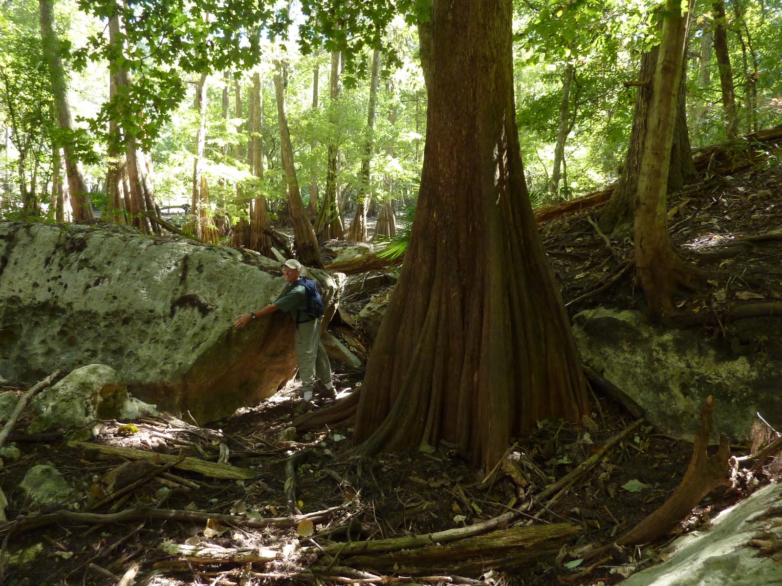
dominated by swamp tupelo, sweetbay, and red maple. This photo shows a typical scene within the ravines:


Here’s one of the forest’s Florida maples (Acer floridanum) with character:


The four ravines are so karstic that they only occasionally, and only for short distances, exhibit signs of water flow. Their surface waters sink directly into the ground and thus into the limestone containing the Floridan Aquifer. Their headwaters terminate at semi-permanent seeps. Rain percolates through sandy Holocene surface sediments, down to the top of the impermeable Hawthorne formation (a sandy, fossiliferous, phosphatic clay), and flows laterally to the edges of ravines to emerge as nonartesian seeps. These little springs show us where the contact is between the two geological formations. More importantly, the seeps create excellent habitat for primitive plants like ferns, mosses, and liverworts:

Creeping Maiden Fern (Thelypteris reptans):


Florida Tree Fern (Ctenitis sloanei):


More creeping maiden fern (photo by Bruce J. Morgan):


These beautiful ferneries, however, are also prime wallowing habitat for feral hogs. The nearly-permanent presence of seepage waters running over sandy clay evidently makes a good foundation for a feral hog wallow, like this one:


Feral hogs at San Felasco also make wallow-like depressions in clay banks that are moist but not wet. Are these mineral licks rather than wallows? Here’s one:


We spotted an unbaited feral hog trap in the uplands near the prairie:


The entrance of Moose’s Echo Cave has changed since I saw it last year. A columnar slug of the Hawthorne formation sediments measuring about three feet in diameter by about six feet long was last year poised to slide down toward the cave’s entrance. It looked so unstable that I dared not enter the cave lest I cause the slug to collapse and cork me in. On the present trip, I noticed that the slug had indeed slid downward several feet, not to occlude the cave entrance but to land immediately beside and east of the cave entrance. A new cave vent opened up between the clayey cliff wall and the slug directly above the main entrance. It was too small for human entry. The cave’s main entrance and the new vent both exhaled cool airstreams. The cave’s entrance is still as unstable as it was a year ago, and again this year I dared not enter it. This is a shot of me standing on that slug, looking into the new opening and balancing on tiptoes in to keep from stepping on ferns (photo by Bruce J. Morgan):


We saw at least one sounder of hogs. We saw them twice within fairly close proximity, both times within the prairie, so I believe they are likely to be two sightings of the same sounder. (A sounder of swine is composed of a dominant female and her young of potentially several generations; mature boars live alone and separate from sounders except when servicing females). Last winter I saw probably this same sounder passing by me while I was hiding in a blind, and I counted 20+ individuals in the group. On another occasion when I encountered them on a hike, I attempted to scare them away by making threatening gestures and noises. Most of the piggies squealed in freight and ran away, but the alpha female stood her ground about 50 feet from me, and doubtless would have slashed my calves with her tusks if I had pressed the issue. Properly chastised, I backed away from the confrontation.

Sanchez Prairie is a long way from any of the park’s trailheads, which is why I use a bike to get there. I consider it one of north Florida’s most ecologically-endowed poljes (large, wide, flat-bottomed, multiple sinkhole). Its forests are mature and extremely biodiverse, it has numerous kinds of plant communities, perched sinkhole pond habitats, and dry sinks, it drains into a karst swallet, supports hundreds of wood ducks during winter, is habitat for turkey, river otter and at least one nine-foot long alligator, has multiple ravines and streams draining into it, and I have never seen other people in there:


I wish we would eliminate its feral hogs.

Saturday, December 4, 2010

San Felasco Trail Mapping

I just can’t stay away from San Felasco Hammock State Park. I did a solo 15.2-mile ride this afternoon with the goal of filling in blanks on my master map of its trails and roads. Before today, I had been lackadaisical about adding waypoints to show where trails/roads start and end, or where I jumped off trail to take shortcuts or explore wilderness, so the master map is kinda snaggley, with hanging trails and horse/bike statuses unknown. I guess I just figured that if I recorded my bike-and-hike GPS tracks, I could sort ‘em out later. Wrong!

The worst depictions are trails that are furthest from the trailhead, naturally, so that’s where I went. Folks, I gotta tell you, 15 miles of my boney butt bouncing around on that skinny, hard bicycle seat has me worn out and sore. I don’t even have the energy to fix dinner, so here I am instead posting to my blog and drinking a beer. But that’s ok! Someday soon, I will have a map of the park that is better than any version I can get online from the state. Maybe it will all be worth it? Wanna buy one from me?

As usual, the trip produced some neat stuff, but less than normal due to my constantly getting on and off the bike to collect waypoints and bury my nose in maps. Here’s the best botanical find today, a crane-fly orchid (Tipularia discolor) leaf:


It is the time of year when the crane-fly orchid produces a single leaf, but is immediately after it flowers and sets seed. Having only a leaf makes it harder to spot the beast among abundant greenbriar sprouts and newly-fallen leaves. This specimen did not have a flower stalk, so if you take just a quick glance at the leaf you might think I have mistaken a greenbriar (Smilax sp.) for an orchid. It certainly does look like the leaves of several local species of greenbriar, but look at this second pic:


It clearly shows the smooth, purple surface of the leaf’s underside, whereas Smilax pumila, the only greenbriar around here with a purple leaf bottom, has a profusion of hairs under its leaves. So it’s a crane-fly orchid, and I am tickled pink to find it in San Felasco. I have been looking for it all my life, yet only saw it recently for the first time (in the mountains of NC), so am glad to know that it occurs in San Felasco. The NC experience taught me the cues to look for, and I suspected it might occur in San Felasco due to potentially appropriate soils and forest habitats, so I was watching for it today. Treasures appear to those who are prepared for them. If you want to see some really good pics of crane-fly orchids in bloom, check out the Nov. 29, 2010 post on The Florida Native Orchid Blog (one of my Favorite Blogs, listed in the right-hand column of my blog) at http://flnativeorchids.blogspot.com/.

Moving right along… In the Trees-with-Character category, I spotted this Southern magnolia (Magnolia grandiflora) on the hillside:


It is a single plant, the trunk in the center being 2+ ft dbh and the two flanking trunks 1+ ft dbh. The central trunk is partially hollow, and I searched for evidence of mammal nests at its entrance, but found none. Its three main trunks have caused the tree’s healthy crown to spread out wider than the norm for this species, so evidently the large wound has not put a crimp on its ability to survive and flourish. We should all be as tough. Peace.

Saturday, October 23, 2010

Blue's Creek Valley Karst

Brack and I did a 13-mile (7 biking, 6 hiking) bike-n-hike today at my favorite Florida state park, San Felasco Hammock. I have many missions to accomplish at San Felasco, but today’s was a new one I had not thought up before. There are two caves out there called Pine Arch Cave and Little Pine Arch Cave, and the Florida Cave Survey states that Pine Arch has a couple of tens of feet of small passage leading to a blowing hole beside a major chert boulder. I had heard of Pine Arch before, but had not heard of the blowing hole, so armed with lat/long from the FCS database, we set off to find it and evaluate the boulder.

Brack and I had walked very close to the coordinates last December without knowing of its existence. We were not all that sure we would have missed it anyway because we look for such karst features whenever we are out in the woods, but we were willing to give it a go. We left my truck at the park’s north entrance and biked about 3.5 miles along single-track trails, stashed the bikes in a clump of native giant cane (Arundinaria gigantea) and walked from there. We found that we had indeed walked right where the caves are supposed to be last December, but this time we saw no caves or even sinkholes where the caves could be hiding below. Oh, there were three sinks in the vicinity, but they were quite well plugged. Possibly, the original lat/longs for the caves were collected via a different datum and then not converted to the datum the FCS uses?

Ok fine, it was time for a backup mission, and I had one at the ready. I have several times been to the swallets that consume all the normal flow from Blue’s Creek, but always reached them from the south following the creek. I have wanted to come in from the north because there is a karst feature I have been trying to re-find for the last several years, so taking the north route today became Plan B. I non-imaginatively call the feature Limestone Pavement Marsh after its tall sedge vegetation and exposed white limestone ground surface. The rock “pavement” may actually be huge, flat boulders appx 15ft x 25ft x 2ft in size, lying not quite flat on the ground, but in any case, they may cover yet another swallet or two. I stumbled upon this marsh a couple of times over the decades, but always without a GPS, which is why I have been unable to re-find them. I can tell you that aerial photos and USGS Topo Quads are truly worthless in this place. Uplands and wetlands are both dominated by hardwoods that appear identical on aerial photos, and the USGS Topos are wretchedly wrong. Perhaps today would be the day we re-found the lost karst?

We set off following the toe of slope at the edge of Sanchez Prairie, rounding a peninsula separating the prairie from Blue’s Creek Valley and headed south. We did not have to travel far before the valley changed from low hammock forest to (dry) cypress swamp, and after progressing only a few hundred feet more along the west edge of the cypress, we hit pay dirt – huge limestone boulders.

Was this it? Was this part of a wetland that would segue into the sedge marsh and pavement limestone of my memory? I felt certain it would be, so I took my time admiring each 10 – 20ft boulder, photographing many of them, but they finally ended at a plugged sinkhole.

Beyond this was a small sedge and smartweed marsh that did NOT have pavement rock. But no, I was not disappointed. Promisingly, there was more cypress ahead that could yet contain the mission marsh, and I was still flush from finding this spectacular karst feature that was totally unsuspected! To top it off, we also found the shed skin of a diamondback rattlesnake, whole but for the rattles.

Happy enough with these things, I rationalized that maybe it was a good thing we had not found the Limestone Pavement Marsh after all, because now I still have that worthy goal to seek. Sometimes, looking for the pot of gold is better than finding it. On a previous trip, Bruce certainly seemed to think so:

Continuing southward we arrived at the location where Blue’s Creek leaves its main valley and flows into two little karst valleys on the west. These side valleys are where the creek’s water drains into the Floridan Aquifer via several small swallets. Each of these short valleys has very steep dirt side slopes with occasional, sheer limestone walls split by fissures into which the creek disappears.

Ordinarily, the first valley’s swallets take all the water, but as the creek rises in storm events or during wet seasons, it overflows the first and then heads into the second side valley, sumping into both of them.

These two small valleys are very picturesque. All exposed rock is covered with mosses and liverworts, spotted here and there with several species of ferns. Florida’s only species of genuine tree fern, Ctenitis sloanei, maintains a couple of ambassadors at the head of the second valley. These are the northernmost individuals of this species I know of in Florida. Half-way up the second valley, 3 – 4ft boulders are imbedded in the substrate and piled atop each other and the lushness of ferns, mosses, liverworts and wildflowers that carpet them is fantastic.


Even trees try to climb the rock!

Fallen logs are abundant along this boulder section, fodder for ferns, fungi and company. Draped over the entire boulder-and-log maze are grapevines and other vines, plus various shrubs. You cannot walk through this habitat upstream of the above photo – it is too treacherous. If you put your weight on the moss carpet, it will slip off the rock like a loose rug and you’ll faw down go boom. Many of the smaller boulders teeter-totter under your weight, plus you must move gymnastically, gingerly over and under the lianas and logs. So don’t! Instead, just stand at the start of it all and marvel. It may be the most beautiful karst valley I have seen in Florida, and I’d like it to stay that way. I have been here before, but Brack had not, and he wisely refrained from blundering in.

Just north of this second valley, another seasonal stream comes into Blue’s Creek Valley from the east and heads south toward the second valley. This stream drains a hardwood swamp. At its western end is a 2ft-diameter willow. Thinking it was an enormous Coastal Plain willow (Salix caroliniana) I was sure I was looking at an unrecognized national champion tree (the largest individual of its species in the US).

I used to nominate national champs and state champs, at one time having about a dozen of them in my portfolio, and continue to keep an eye out for unusually big trees. Brack and I estimated height/ diameter/ crown spread dimensions to use in checking the books back home, knowing that if it indeed is that worthy we would have to come back with a tape measure to obtain real numbers.

It could also be a black willow (Salix nigra), which can grow to a diameter of 5ft or more, but I have never seen this species on the Florida Peninsula. There is always a first time, so I collected a twig with leaves for later identification. CP willow has whitish undersides to the leaves whereas black willow’s are green like the leaf dorsum, and this tree has green leaf undersides (= black). However, tiny glands at the tips of leaf margin teeth are red on black willow and yellow on CP willow, but this tree’s leaves have orange glands and the book says the two can intergrade. If this were mid-summer and the leaves were turgid and strong, I would be satisfied to call it a possible intergrade, but we are late in the season when leaves are dying, so the red could easily be fading to orange (or even yellow?) by now. I shall have to wait until spring to find out for sure. I plan to notify park management about it next week anyway, because regardless of whether it is a black willow or an unrecognized champion Coastal Plain willow, it is a notable tree that warrants protection.

Peddling back to the parking area, we saw the Traveling Gnome that someone moves around the park:

Wednesday, January 20, 2010

Needle Palm Creek

Last Sunday I explored in the SE part of San Felasco Hammock State Park that lies north of Millhopper Road. I parked in the hiking parking lot and rode my bike 1.5 miles east along Millhopper, darted into the woods and hid the bike. The day’s goals were to explore the highlands-karst transitional zone in sections 7 and 8, T9 R19. As usual, I found clear water streams fed by seeps, sinkholes and feral pigs. Following one stream northward to Blue’s Creek, I then turned ESE and followed Blue’s to Fox Pond, a recent addition to the park.

The total hike was about 7.6 miles, and I gotta tell you that I am soooo glad I pedaled 3 miles or I would have had to walk over 10. I have been ranging further and further from the trailheads, both hiking and biking, and am nearly at my sore feet’s limit. There may be places in San Felasco that I never get to see. Oh, the sorrow!

I am calling the first creek I walked down Needle Palm Creek in honor of the large, glossy, abundant palms at the toe of the feeder seeps and along the first quarter-mile or so of the stream. Here is a pic of Needle Palm Seep with attendant palm:


These seep streams join other seepage discharges to form a second order streams. This is where I ate lunch beside three log bridges:


I ran across several sinkhole ponds containing water, buttonbush and graminoids that were evidently just right for cricket frogs (Acris gryllus) and spring peepers (Pseudacris crucifer) to form mating choruses. Man, were they loud! I flushed a few deer along the way, including this one-antlered male that patiently waited until my camera was ready. He then he let me take exactly one picture before he bounded off:


The pigs I encountered were not too afraid of me. My current MO is to pretty much ignore them as I walk by so they will neither see me as a threat to attack nor a hunter to fear. My plan is to be able to get close to them without fear of injury so that one day if/when I get permission it will be easier to cull them.

If you want a walk of solitude, I can assure you that these SE creeks are rarely visited. Along the shoulders of their ravines are game trails that you can easily find and walk. Oh, it won’t be a cake walk – there is plenty of brush, fallen logs and vine tangles, but for the most part, it is wild and pleasant.

Thursday, December 3, 2009

San Felasco Sweetgum Seed Rain

A couple of cavers came down from Tennessee last weekend to relax in Florida’s warmer weather, so Bruce, JJ and I took them out to San Felasco Hammock State Park for some biking and hiking on Saturday. We took the Cellon Creek Loop (south) bike trail to the Tung Nut Loop bike trail through an overgrown field to Sanchez Prairie. At that point, the Tennesseans had to turn back due to one of them just not quite being over his recent head cold. Bruce, JJ and I abandoned the bikes at the edge of the prairie and continued on foot from there. We hiked first along the toe of the prairie’s western slope to the third tributary, then wandered westward along the edge of that little karst valley to its head, from which we hiked back to the bikes along the “highland rim” of the prairie and then biked back to the vehicles. My GPS recorded 7.5 miles of biking and another 3.0 miles of hiking – an easy day, for once! Well, it‘s easy if you’re not sick.

The layout of the karst valleys is interesting to me. Imagine three lines of sinkholes developing in impermeable sediments atop soft limestone, trending in fairly straight lines (lineaments) oriented roughly east to west. Give those lineaments a little geological time and a couple of things happen. First, the sinks expand until they coalesce, and second, new sinks form westward of the last ones. By this process, the valleys undergo headward erosion and extend into the uplands. Unfortunately, very little rock is exposed and no caves are apparent.

Seepage springs occur at the head of each valley and occasionally along the lower slopes of the valleys. These lateral seeps are heavily damaged by feral pigs, which root up anything edible to a pig and then wallow in the clayey spring run bottoms. Whatever ferneries might once have existed in these places are now reduced to a few sprigs here and there. I saw a group of feral pigs a few weeks ago in the third valley, and we saw a group there again on Saturday. Based on the number of pigs, their sizes and coloration, I suspect this is the same (family?) group I saw before. A predictable nuisance is a manageable nuisance. Is anyone from park management reading this?

We did not see any feral pigs in the prairie bottom, but then I didn’t see any feral pigs in that part of the bottom last time, either. Perhaps that area is part of the territory of the pigs in the third valley.

Upon returning to the bikes, Bruce and JJ noticed they were being “rained” upon by tiny objects. From my more sheltered location it sounded like they were being pelted by aphid honeydew, but when I went over to them it became immediately obvious what it was. Back in 1971, I was walking across the University of Florida campus at, well, probably exactly this same time of the year through a monocultural stand of small but mature sweetgum trees. As I stopped to look at something I have since forgotten, the faint sound of a light rain could be heard, but instead of tiny droplets on my sleeve there were tiny seeds from the sweetgums. Evidently, sweetgum seeds dehisce simultaneously and then fall in one or more episodes over a short period of time. That is what Bruce and JJ had noticed – a sweetgum seed rain! When looking at darker backdrops like a downed tree trunk we could readily see the seeds falling abundantly. What a pity that our cameras were unable to video the event. It was only the second time in my life that I have experienced a sweetgum seed rain, and was a first for Bruce and JJ.

Incidentally, sweetgum seeds contain shikimic acid, the starting ingredient for making antiviral drugs to combat bird flu.

Saturday, November 7, 2009

Sanchez Prairie (Saturday's Serengeti)

I got an early start today, arriving at the San Felasco SP bicycle trailhead and scooted off about 0930, following Cellon Creek trail to the power line and southward. Always before I have passed the barn where the dairy used to be, but this time I veered west a little to check it out and the large sinkhole close by. The sink was dry and without any limestone showing, but they say there is a barn owl in the barn, and I spotted this 2m yellow rat snake on a log nearby:


I thanked the snake for letting me see it and warned it about the owl, and then headed on southward following a bike trail thru an old field growing up in young loblolly pines and sweetgums, and Spanish needles (Bidens pilosa) galore. My pants and shoes, and exposed socks, snagged quite a few of their centimeter-long, half-millimeter wide seeds that have two 3-mm retrorsely barbed spines on one end. The spines stick into clothing and then the barbs start ratcheting the needle deeper into the clothing when you move, and soon you are being jabbed by few little needles here and a few more there. You stop and pick the worst of them out, being thankful for the short rest, and then move on.

Down the Tung Nut Depot trail, I rode thru a beautiful deciduous hardwood bluff forest to the north edge of Sanchez Prairie west of the powerline and stashed the bike. Now for the real fun - moseying. I walked pretty slowly counter-clockwise along the edge of the big wetland polje, with the bluff forest on my right. Coming to the northwest corner of the ponded water, I walked to within less than 10 meters of a nearly 3-meter alligator because I didn’t see it. I was looking upward at a flock of migratory yellow-rumped warblers that were being scolded by local Carolina wrens and Carolina chickadees, and I guess the big ‘gator figured it wasn’t in too much danger, for it only slowly did a U-turn in its muddy slide and languidly slithered into the water under a floating mat of frogbit. There are times when I’m glad we don’t have top carnivores like lions and hyenas around here. I thanked the ‘gator and moved on.

I explored the uplands to the west of Sanchez Prairie. Boring young pines and such, they are, and the patch of Spanish needles of the world! Oh, man, I came out the other side with major needles stuck below the belt. They were burrowing thru two layers of socks into my ankles, so I had to take 20 to pull them off. Mr. GPS then logged more sinkholes and ravines while walking back to the prairie’s southwest corner. There was a family of feral pigs, a sow and 6 young ‘uns just uphill of the prairie in a moist ravine. Check out this hog wallow in a seepage spring creek:


I am in awe over the huge amount of wildlife I saw today. I am going to list it and you aren’t going to believe it. There were two yellow rat snakes and two alligators. This smaller ‘gator is only about 2 meters long:


I ran across 4 or 5 (they backtrack and confuse me) families of feral pigs, each having 5 – 7 members. They forage mostly on moist to wet ground around the prairie’s perimeter and up the centers of larger tributary ravines. Here is a photo of the edge of a pond within the prairie:


Notice a couple of things here, first the countless pig tracks in the mud just up from the water’s edge. Second, there is a meter-wide open waterway between the mud and floating frogbit. Can you see the alligator track on the left, moving away from the camera and then cutting left into the vegetation? That waterway at the water’s edge is maintained by alligators slowly moving around at the water’s edge. You know what they say? “Don’t turn your back to the water!”

Along the edge of the pond where numerous small tree trunks <15 cm diameter emerge thru the stagnant, duckweed-covered tannic waters there were wood ducks. I don’t know if I was just flushing the same few repeatedly, like egrets flush while you’re canoeing down a river only to land a few hundred meters downstream where they will just flush again, and again, as you continue to float down. Otherwise, I might have seen 75 – 100 wood ducks in the space of a half-hour. Then the dickey birds were everywhere, and blackbirds were massing in an open-canopy part of the wetland forest where 3 destructive hurricanes came thru here several years ago. This picture will give you some idea of the damage the ‘canes did:


I doubt I have ever seen so many whitetail deer in a single day in my life. Did I see 50? Did I see 100? I never did start counting, but here are 3, there are 5, around the next bend are two groups of 4 and 5, and on and on. You know what you get when you don’t hunt big animals? You get deer all over the place, and they are sort of tame, too. If my path took me directly toward one, it would casually bound a few steps to the side and then stop, chow down on something green and then flick its ears at me, but they were not afraid. I just walked on by them, pointedly not making eye contact.

You also get pigs all over the place when there’s no hunting. The pigs would snort and stampede when they caught wind of me a few meters away, but when I neither chased nor shot at them they would stop, turn and face me, and watch as I walked on by. They never mess with me, pigs. Smile for me the next time you hear a beerbelly counting coup about how a hawg attacked him with “tushes THIS BIG!”

Oh, I almost forgot: Do you know why there was so much wildlife out there today? Acorns. Everywhere around and within Sanchez Prairie above the waterline is dominated by oaks, mostly diamondleaf oak (Quercus laurifolia), but also shumard oak, swamp chestnut oak, water oak and live oak. The bluff forest also has abundant pignut hickories that are dropping a moderate hickory nut crop this year. Wood ducks, feral pigs and whitetail deer depend heavily on mast (nuts) this time of the year. It is a seasonal crop, and perhaps they come from all around the nearby countryside to harvest the bounty that Sanchez Prairie has to offer. I know I do, thank you.

Monday, November 2, 2009

Blues Trace

Yesterday, I returned to San Felasco State Park with Bruce for a 10.3 mile bike and hike to nail down some karst features that are impossible to locate from topo maps and aerial imagery, and to have some fun. Blues Creek heads up just north of Millhopper Road in Gainesville, FL near the SE corner of the park. It drains surface waters during wet seasons and is kept wet by discharge from seepage springs during most of North Florida’s dry seasons (spring and fall). Blues Creek travels north from its origin through a moderately steep ravine dominated by a mature forest composed of mixed, semi-evergreen hardwoods. Shade from the forest canopy that the creek is embedded within is so dense that most of these woods have little brush, giving a park-like ambiance to the area.

Parallel to Blues Creek for a short distance is a karst valley that I will call Blues Trace until I learn what FDEP calls it. The valley is really a ragged line of deep, steep sinkholes that pond water up in serious or quickly-repeated storm events. This is one of the longer and deeper sinks, with Bruce for scale:


Blues Creek travels northward until it reaches a swamp forest, where it then flows within a wider, shallower, braided channel clockwise around the south side of the swamp. There are at least two blind valleys that extend to the south and west off the creek channel beside the swamp. The eastern blind valley has walls that are steep but climbable if you are healthy, and a floor of wet sand and mud, and logs galore. Blues Creek today runs through the western blind valley and sumps into a series of crevices at the base of the valley’s limestone walls that are too small to enter. Here is a portion of this very beautiful karst valley:


When it come to Florida karst scenery, it doesn’t get any better than that. We saw a 3ft long cottonmouth the last time we were here. Of course, the moccasin never threatened us. I have also seen downy nestling vultures hiding among these rocks several times over the years, and Florida tree fern (Ctenitis sloanei) maintains a small, possibly its northernmost Florida population in this valley (the USDA has records only as far north as Hillsborough County although I have seen it well north of that occasionally). The terminus of the valley has walls that are too steep and clay-slick to climb, and we didn’t want to do that anyway due to its splendid fern cover. You have to backtrack to get out of there. The only other people I have ever seen wandering around waaaay off-trail in the park were a couple of fellow naturalists at this spot. The place is a subtle magnet to my kind.

A major lineament (bedrock fracture) connects Alachua Sink in Payne’s Prairie to Hornsby Spring. Dye tracing has proven that several stream swallets only a mile or two north of this lineament connect to Hornsby Spring via underground conduits. These include Cellon Creek Swallet at the head of the San Felasco bike trailhead, Mill Creek Sink (an NSS-owned cave diving site) and another sink I don’t know the name of that used to channel the General Electric battery plant’s acid waste into the Floridan Aquifer. Sanchez Prairie almost certainly drains into that system – its swallet is almost dead-on the lineament. Blues Creek Swallet almost certainly feeds into that lineament too, as it is also only about a mile north of the lineament. Furthermore, Blues Creek Swallet may make the connection to the lineament via Blues Trace. Unfortunately, the known caves in this part of the lineament’s cave system have ceilings at 190ft to 220ft below the aquifer’s water level and there is plenty of overburden available to plug any solution pipe that might open up along Blues Trace, so it will take a dye trace to answer that question.

Sunday, October 25, 2009

San Felasco and Gum Slough

The San Felasco Hammock Preserve State Park was the choice for Friday’s bike and hike. Bruce was recouperating from a bout with the flu, so we got a late start and only wandered about 9.5 miles that day. Using the GPS, existing bike and horse trails, and a variety of maps (topo, Google Earth, park trail maps), we were able to fill in some more of the puzzle (to me) that is the karst valley that ends in Sanchez Prairie. San Felasco is a special place that I never tire of exploring. It may be the closest thing around here to a large area of mature, natural vegetation spread across the transition zone between the impervious Northern Highlands and the karstic Newberry Plain. San Felasco also has small pockets of true “Old Growth Forest” if you know where to look. I know some of them, and continue to look for others.

San Felasco is pretty big for day trip explorations on foot, horseback or bicycle (no overnighters allowed - but maybe along the Florida Trail here?). The karst valley we are trying to tie down is smack in the middle between the north and south entrances to the park, there are no roads to it, the only trails to it are horse trails that bicyclists aren’t supposed to use, and the topography has a lot of ups and downs. In a nutshell, it is an aerobic little adventure to get there and another to come back, but they’re good ones. IMO, the trails are as challenging as the trails of the nationally renowned Santos Bike Trails Area, but are more scenic at San Felasco and are paths less traveled. The trails at Santos are on severely impacted property supporting raggedy early successional pine and hardwood forests plus old abandoned barge canal segments plus spoil piles and borrow pits and the like. It’s a great place to ride on red trails, though, and certainly more appropriate than San Felasco for ambitious, healthy mountain bikers who are not naturalists. Some of the trails at San Felasco are within early successional forests, too, but most of San Felasco’s trails run through mature hardwood forests or even older growth climax hardwood forests. Plus, the slope forests along the northern edge of Sanchez Prairie have that oak-beech look without the beech, but we can imagine…

On Saturday, Bruce, Brack and I did a bike and short hike trip at the Half Moon Wildlife Management Area in Sumter County, FL. The property encompasses 9,480 acres in the southeast corner of the confluence of the southern Withlacoochee River and Gum Slough. We got a late start on this 12.4-mile ride due to first attending an environmental expo in The Villages. We biked the main limerock road from the parking area at the northern end of CR 247 northward about 4 miles to Davies Road, intending to ultimately stand at the edge of Gum Slough Creek. There is a dirt road through the woods between and roughly paralleling the main road and the river-slough floodplain that would take us back to the parking area. We had intended to return via that route, but at that late hour it would have resulting in a death march along an unkempt road through hordes of ‘skeeters after dark. Nope. Didn’t.

Along Davies Road, we found a relatively easy route down into the Gum Slough floodplain where we stashed our bikes and hoofed it downhill. We almost made it to an eastern braid of the stream, but elected to keep our feet dry. This floodplain is not very level, but rather is crisscrossed with flood channels, natural streamside levees and natural rounded and elongated hillocks. Wet areas closer to the stream braids are dominated by mostly deciduous hardwoods like red maple and swamp tupelo, but we saw at least one pretty large sweetbay (Magnolia virginiana) almost 3 ft in diameter. The higher elevations supported a mature mid-successional mesic hardwood forest while intermediate elevations were dominated by a semi-evergreen hardwood forest dominated by live oak (Quercus virginiana). The latter habitat is also called “low hammock,” and is my favorite woods that we visited that day.

This low hammock is dominated by “too much” live oak, if there is such a thing. I say the former because it might compose over 50% of the overstory canopy, and I say the latter because live oak is a special tree. Driving down the highway you can see scads of live oaks out in Florida’s horse pastures. Their enormous 6-, 8- and 10-ft diameter trunks rise about a dozen feet off the ground and then multiple brontosaurian-necked limbs soar up and out and swoop down and spread out to form a hemisphere of photosynthesis a hundred feet in diameter and half that in height. Their limbs and trunks will be partially coated with resurrection fern and Spanish moss will cascade from their branches. If abandoned, that pasture will grow up into a forest dominated by those hemisphaerical, “open-grown” elders. You walk through that forest and think you are in an ancient copse because of the mightiness of their trunks, but in many cases they are less than a hundred years old, so don’t be fooled! The next step in the successional trend of the forest is exemplified by the low hammock habitat along Gum Slough, which you can see behind the below-pictured live oak:


Look at the form of that tree. Obviously, it is not a hemisphaerical, open-grown tree. That trunk rises almost straight up for about 45 feet before it first branches, and the trunk at that height is about 3 ft in diameter. This is a forest-grown tree, one that got its start in a small clearing that was created by a tree dying there long ago, allowing sunlight to reach the mature second-growth forest floor to energize the live oak of today. Notice the trunk is covered near the ground by bryophytes (true mosses). If you could see the limbwork high over Bruce’s and Brack’s heads, you could observe that resurrection fern and Spanish moss have been joined by several more epiphytes like ball moss, Bartram’s moss and several other Tillandsias, plus two orchids, the green-fly orchid (Epidendrum conopseum) and Tampa butterfly orchid (Encyclia tampensis). In truly old-growth live oak forests, there are more species of trees in the overstory and live oaks have a much higher density of epiphytes, at least in low hammocks.

The next time I visit Half Moon, and I certainly intend to, I will take the woods road and go looking for karst outcrops along the river and slough floodplain and its edge. Let me know if you want to go.